Over the Mountains and Across the Fjords
“To understand a city, learn its streets. To decrypt a nation, read its roads” so was I once advised.

Somewhere between Flam and Geiranger, I furtively chased a road. It bent at improbable angles to hide behind the mountains, and reappeared in a truncated form, half eaten by the clouds that had descended unannounced, regained form again but only to slope down and dissolve into a patiently waiting fjord. The waiting ferry would connect me to the asphalt hanging loose at the other end, from where the pursuit began all over again. The pattern had repeated multiple times over the two thousand or so kilometers that I had spanned in Norway so far.
I stepped out for a breather. The valley was quiet, except for the slow thump of the marine engine. The sun was hidden behind the mountains; its absence rendering a touch of gloominess to the ambiance. Noticing me standing alone at the top deck in quiet reflection, Reidar approached me. He spoke English haltingly, but with enough clarity to allow a conversation. I had noticed him earlier driving a Tesla Model S behind me and had waved out.
“So why am I noticing Tesla all over Norway”, I asked as we sipped coffee to palliate the chill of the wind.
“Well, Tesla’s second largest market in the entire world is this tiny country”, Reidar explained with certain seriousness, “we value cars that are environment friendly, and if you buy an electric car, the annual registration fee is waived, as are tolls, and you get access to less-congested traffic lanes.”

What’s not apparent is that all of those little extras are funded by the country's sovereign wealth fund, a massive $860 billion rainy-day cash pile largely made up of oil money. Along with a stunning landscape, Norway also possesses a rich economy, skewed into a single track given its oil dependency. However, the garishness of oil production is confined to the North Sea and does not spill into the interiors. From the calm waters of the fjords, the men seem in agreement with the nature. Elsewhere, it’s a different story.
The meeting with Reidar turned out to be a fortuitous one. He owned a lodge that he rents out near Geiranger, and I of unplanned adventures had no place to while the night away. So I followed him to the lodge atop one of the ski slopes laden bare at this time of the year.
Geiranger is a small tourist village in western Norway, situated alongside the eponymous Geirangerfjord, a fjord that has been listed as a UNESCO World Heritage Site. Later that night, in Reidar’s well-equipped wooden lodge, with a cup of tea in hand, I looked out to the fjord that glittered in the fading light. This was my last night of the journey, and I reflected back on the last three days.
I was in Norway to track some famed classical mountain roads. I had started my journey in Malmo, a violence prone fractured industrial town in the south of Sweden that has become an entry point for refugees into the country. The landscape from Malmo to Oslo, the capital of Norway, is flawless, unwaveringly flat, and boring, except for a few glimpses of North Sea that has the tendency of popping out once in a while. Gaze a bit harder, and one might catch the outline of Denmark on the other end of the water on a clear day.
It’s only after Oslo that the roads gain a gradient. As the road slants upward, temperate mixed forest of pine, yew and oak, line alongside. Higher up, more typical boreal forest takes over. The fjords would make an appearance later, farther out in the west. But once these water bodies spring up, they remain a constant for the rest of the journey.
Flåm, a small hiking town of 350 residents but receiving almost half a million visitors a year, was my first stopover. There are few things that make Flåm interesting: it’s ideally located to start hikes to the fjords of Aurland and Sogne; it nestles one of the steepest railway tracks in the world; and it leads onto one of the best roads to drive on, the snow road.
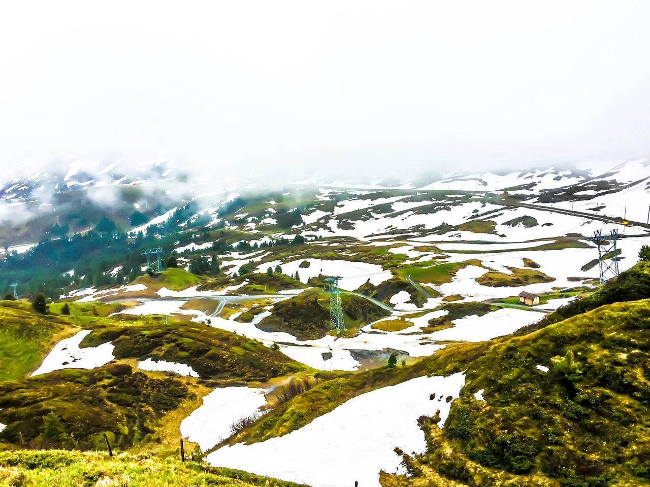
The snow road is tucked away from the main E16 highway. The tourist office in Flåm guided me to the secret passage that nestles it. No one uses it for conventional travel anymore. The local motorists prefer the Lærdal Tunnel, which is a straight line tunnel passing through the three mountain halls and that, at 24.5 kilometers, is the world's longest road tunnel. The snow road connects Aurland to Lærdal and has its highest point at 1,306 meters, which is not significantly high, but the snow line in these parts start early given the interplay of altitude and latitude.
The snow road is a difficult drive. Most of the ascent is constituted of a single lane that at times also accommodates tourist buses. Anyhow, once the steep climb is negotiated, the road widens into a barren plateau covered in a layer of leftover snow from the last winter. Pond size poodles of melted snow and sprigs of grass punctuate the landscape. It’s the desolation that renders this plateau impressive.
Driving through these mountains could be a lonely pursuit. The routine is interrupted while filling gas at a petrol station or buying coffee at a local supermarket. At one such pause, I met Tor who had noticed the Swedish number plate on my car.
“It’s interesting how the world works. I am heading to Sweden to my summer house, and Swedes are coming to Norway for their summer holiday,” he commented with a smile, “something got to move all the time!”
I offered some excuse for leaving the relative warmth of southern Sweden to come to the snow covered mountains in Norway. Tor is a journalist with the biggest newspaper in Norway, with a circulation of 250,000. After some years of living in Scandinavia, I have learnt to not get scandalized at such figures qualifying for the maximum. Tor helped me plan the journey afterwards. GPS does not allow the luxury of chalking routes in ink, a preference that both Tor and I carried. So we bought road maps that covered some of the National Tourist Routes in Norway. It was through Tor that I understood the origins of some of these very famous drivable roads in Norway.
“It’s a big project for the folks at the Public Roads Administration”, Tor explained, “the objective is to develop the infrastructure behind the National Tourist Routes, and keep on identifying new ones, so as to attract tourists.”
“So these roads are not just naturally beautiful,” I tried to distill what I had heard, “but they are beautifully designed.”
As of today, there are 18 different National Tourist Routes in Norway. I had covered one, and with a blue ballpoint, Tor marked the other two that I planned to cover next.
Tor got ready to drive away in the other direction, charting the same route that I had so far covered. “And don’t forget to sit on one of Hølmebakk’s viewing points. Take out time to soak in!” was his parting advice. Carl-Viggo Hølmebakk is a prize-winning Norwegian architect who has designed several viewing points on these roads.
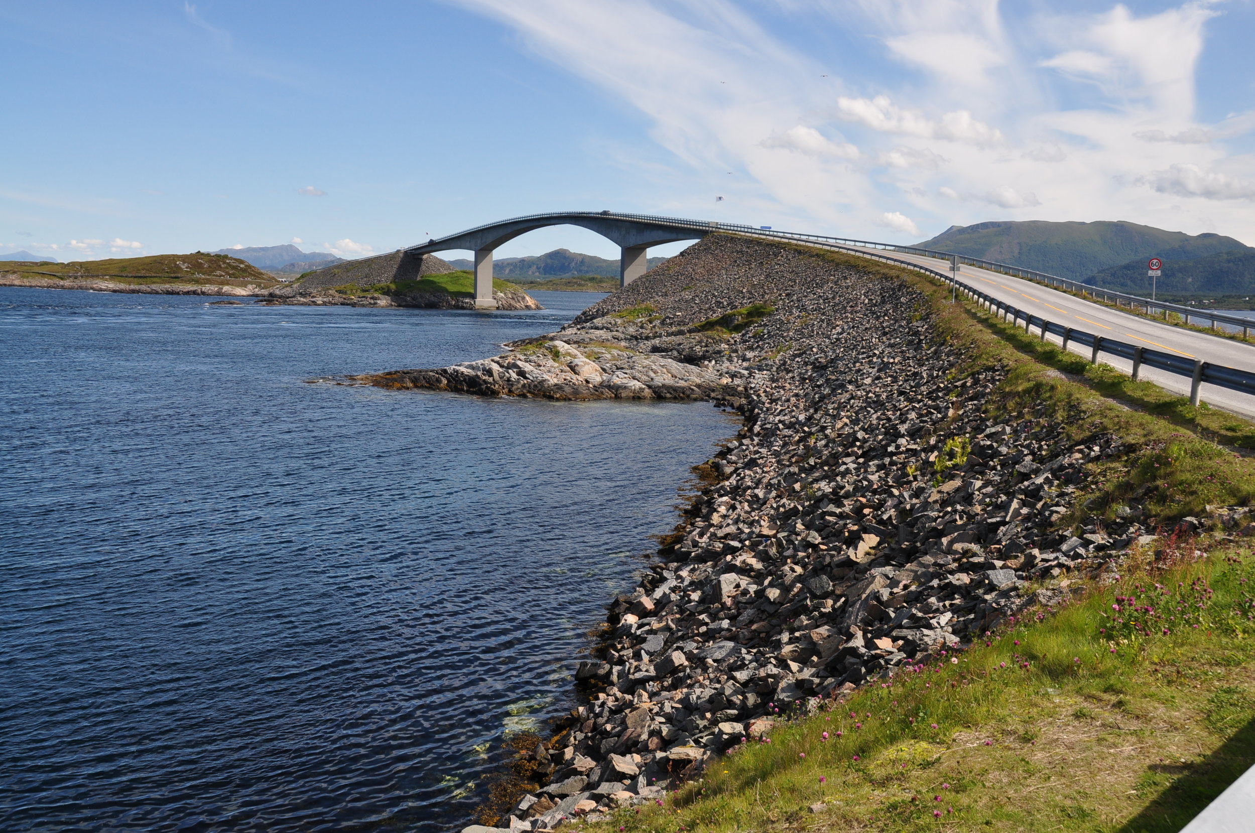
The Atlantic Road is a prime example of how Norwegian Public Roads Administration has converted the relatively straightforward task of putting tarmac into art. This eight kilometer stretch on route 64 joins the coastal communities of Kristiansund and Molde. It took me two ferry rides from Stranda to reach the starting point of this maritime road. The most prominent sight of the road is the cantilevered bridge that juts out of the ocean as a curved bow pointing towards the sky. A swift dive from the curved bridge leads to a rest area on a small island where tourists can park their cars and take a walk around the island on a metal pathway. The pathway rests on a mesh mounted on poles and channels the human traffic in a predefined route, making the marshy terrain below free from any unwanted human intervention.
I sat down on the meshed footpath and looked out into the pale blue Norwegian Sea that lay spread out in the front. This was the furthest out in the west that I have been in Norway. Norway is shaped like a baseball bat, and the Atlantic Road is a well suited to start the journey north along the narrowing handle. However, time was a diminishing asset and more roads waited to be covered.
Trollstigen constitutes a major part of the 150 or so kilometers that connects the Atlantic Road to Geiranger. One of the highest paved roads in Europe, the name of this road roughly translates into ‘troll’s steps’; the Norwegians have given this road a mythical name to signal its serpentine nature and altitudinal variations that mark it. The gradient at some places is as much as nine percent, and such steep climb together with hairpin bends makes this road both scenic and a challenging one to drive on. At one such bend, the right hand side tires of my car scraped against the thin cemented boundary along the edge, and for few seconds I lived in the mortal fear of falling down 400 meters into the gurgling Stigfossen waterfall below.
Driving in these far-off mountain slopes could at the same time be an immensely liberating and an equally shuddery experience. The feeling of being one with the elements could fast turn into that of helplessness. Chastened by the experience, I stopped over at a resting place at the top of the mountain to quieten down. At 700 meters, this resting place had a car park, a restaurant, and several souvenir shops. Further inside, the buildup opened into the rocky landscape tamed with wooden pathways and several viewing balconies that overlooked the bends in the road below and the Stigfossen waterfall. I walked to one of these viewing balconies and while scouting around realized that unwittingly I have ended up at one of the famed Hølmebakk’s creation.
Looking far out from these viewing platforms, a certain realization began to seep in. I had come to these slopes to find the best roads in Norway to drive on. I had driven from one to another, always hoping for the next experience to better the previous one. As I stood on this balcony hanging in thin air, I was far away from the motion below. I watched the caravan of cars and busses course the anguine road in the hope of catching the same excitement that I have had. For me there were no more roads to be pursued. My way forward was my way back to where I first started. Somehow, I felt released and happy. So I sat down on one of the oddly placed Hølmebakk’s wooden creation and followed Tor’s recommendation. I soaked in the moment.

A version of this story appeared in Outlook Traveller